Use this page to find out about the proposed improvements to the walking, wheeling and cycling links near Bath Quays Bridge.
Project and strategy context
We aim to provide more travel choices for everyone. As part of our Corporate Strategy, we want to make walking, wheeling, and cycling safer, more convenient and accessible, while helping to reduce congestion, improve air quality and promote healthy lifestyles.
Bath Quays Links (BQL) is an initiative designed to help make walking, wheeling and cycling easier, and more enjoyable, in central Bath. It is one of several CRSTS (City Region Sustainable Transport Settlements) projects being developed in Bath. It will work alongside other transport strategy initiatives in the city, to support our community's travel choices.
Its focus is the walking and cycling bridge across the River Avon which opened in 2022, providing improved access for the Quays developments and into other areas of the city and beyond.
Previous public engagement
We previously consulted on proposed active travel facilities to connect the new bridge at the Bath Quays development into the existing network in 2022.
Upcoming works
Select a road from the list below to read in detail what we plan to do:
We're providing:
- new cycle lanes on both sides of the road between Westmoreland Road and Oak Street, including bus stop bypasses to route cycles behind bus stops.
- a new puffin crossing for pedestrians east of Westmoreland Road/Riverside Road.
- conversion of the existing pedestrian crossing next to Aquila Court into a toucan crossing for both pedestrians and cycles.
- improvements to the road and footways between Westmoreland Road and Oak Street with removal of steep footway gradients and drainage improvements to reduce flooding.
We're providing:
- a new two-way cycle lane on the west side of Green Park Road. It will be at the same level as the carriageway but separated by kerbs on both sides, providing a safe environment for cycling and maintaining a footway for pedestrians. A bus stop bypass will route cycles behind the northbound bus stop.
- a new zebra crossing adjacent to Bath Quays Bridge
- reallocation of the existing zebra crossing near Green Park House
The scheme will integrate with proposals for a two-way cycle lane on the west side of Charles St (part of the Bath City Centre project) and proposals for a two-way cycle lane on the west side of Queens Square (part of the Bath Walking, Wheeling and Cycling project)
View the proposals on a map
Our current proposals affect the area highlighted in blue on this map of the Bath Cycle Network.
We are constantly working to create and improve the network to make it easier and safer to get around the city using modes of active travel.

The graphics below show an illustration of what the route will look like once complete, for Green Park Road (top) and Lower Bristol Road (below).


Proposed construction dates
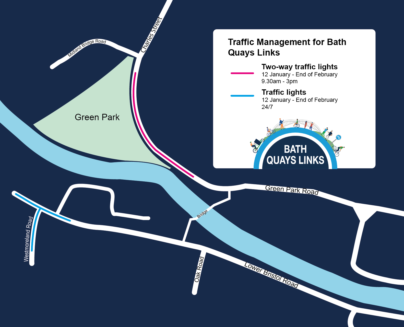
Construction of Bath Quays Links began in October 2025. Efforts have been made to ensure disruption is kept to a minimum. There will be traffic management in place such as traffic lights.
See a graphic of the traffic management for this project.
| Site name | Planned Start | Estimated Duration | Works Summary |
|---|---|---|---|
| Lower Bristol Road | 12 January 2026 | 9 months | New cycle lanes, bus stop bypasses, new/improved pedestrian/cycle crossings, improved roads and pavements. |
| Green Park Road | 20 October 2025 | 10 months | New cycle lane, new zebra crossing, improvement of existing zebra crossings. |
Key project aims
- Providing safe, accessible and enjoyable walking, wheeling and cycling routes
- Adding walking infrastructure to enable active travel
- Increasing safety for those choosing sustainable methods of transport
- Linking up to existing and planned cycling networks in the city
How Bath Quays Links connect to the wider network
The new scheme elements offer the following links into existing or planned networks:
- Direct interfaces with:
- Bath City Centre project at Green Park Road/Charles Street
- Bath Quays North development
- Connectivity links with:
- National Cycling Network route 4 and the proposed route to Weston, via Bath City Centre and Bath Walking, Wheeling and Cycling schemes
- Bath Riverline (River Avon towpath)
- Green Park Green Space project
- Future opportunities for walking, wheeling and cycling improvements to the west and east on Lower Bristol Road and Claverton Street
Why walking and cycling are important
We need to make walking, wheeling and cycling the natural choice for a lot more of our journeys. Currently, over a third of car trips across Bath and North East Somerset are less than 5km.
The importance of walking, wheeling, and cycling, or ‘active travel’ as an affordable and accessible mode of transport has become increasingly apparent over recent years.
The benefits of active travel are extensive - from improving air quality to ensuring healthier places and people. By enabling more travel options, we can optimise road space for all.
Active Travel Masterplan
The routes are part of our emerging Active Travel Masterplan, a comprehensive plan that sets out the existing and future network of active travel infrastructure.
It aims to enable walking, cycling, and other forms of active travel, ensuring safer, healthier, and more accessible transport options for everyone. It will support all types of journeys, including commuting, education, leisure, and tourism.
View the Active Travel Masterplan page to find out more.
Project timeline
| Date | Stage |
|---|---|
| July to Aug 2022 | Public consultation on draft proposals |
| 2023 to 2024 | Refining of proposals and scheme development |
| Jan 2025 | Complete detailed design |
| April 2025 (complete) | Submission of Full Business Case to West of England Combined Authority |
| Summer 2025 (complete) | Full Business Case approval |
| Spring/Summer 2025 (complete) | TRO (Traffic Regulation Order) public consultation |
| Autumn 2025 | Construction starts |
Keep informed
If you have feedback or questions about this scheme, please email us at baths_quayslinks@bathnes.gov.uk. You can also subscribe to our newsletter or follow us on X (formerly Twitter), Facebook and Instagram."

