On 1 November, we installed three, linked through-traffic restrictions in Gay Street, Catharine Place and Winifred’s Lane under experimental traffic regulation orders (ETROs) for a minimum of six months. The public consultation for each trial ran from 1 November 2024 until 30 April 2025.
Why we are consulting
We use ETROs to see if schemes work in practice while monitoring the impacts and inviting feedback as people experience the trials over a period of six months. We will analyse and consider this information before deciding whether to permanently adopt the linked restrictions or remove them. The trials will remain in place until a decision is made.
Purpose of the trials
The trials in Winifred’s Lane, Catharine Place and Gay Street have been introduced under our Liveable Neighbourhood programme. In line with the broader objectives of the LN programme, the restrictions aim to:
- reduce excessive traffic in residential areas
- keep through-traffic on the main road and disperse local traffic across a wider area
- create safer routes for walking and cycling through the area
You can continue reading to the ‘Scheme overview’ section on this page, where you’ll find more information on each trial and links to annotated maps and drawings.
The trials are an outcome of earlier public engagement with the community, outlined on the Lower Lansdown and The Circus Liveable neighbourhood web page.
Scheme overview
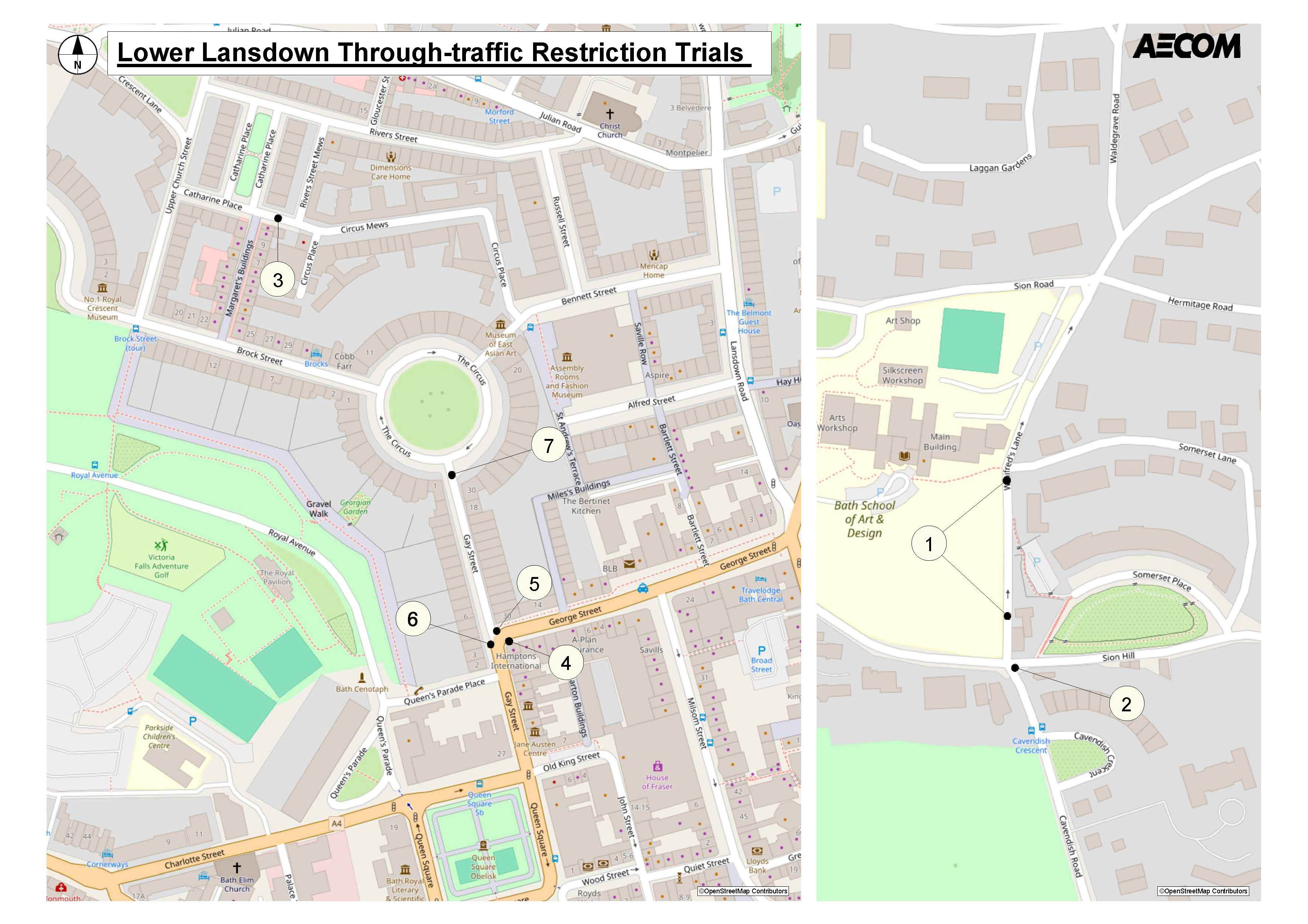
The numbers on the map above, correspond to the annotations below.
Winifred's Lane through-traffic restriction
Installed on Wednesday 6 November.
- (1) A through-traffic restriction on Winifred's Lane comprising of one set of bollards placed just north of Holywell House and one set of bollards placed just south of Somerset Lane
- (2) A no right turn into Sion Hill (east) from the top of Cavendish Road applying to motor vehicles but not cyclists
View the Winifred's Lane scheme in more detail.
Gay Street traffic restrictions
Installed on Monday 4 and Tuesday 5 November.
- (4) A no-entry into Gay Street from the George Street junction applying to all northbound vehicles but not cyclists
- (5) A left-turn-only into George Street for vehicles exiting this stretch of Gay Street
- (6) Vehicles are prohibited from travelling south to Queen Square when exiting this stretch of Gay Street
- (7) Two-way traffic is maintained on Gay Street, but with entry only via The Circus
View the Gay Street trial in more detail.
Catharine Place through-traffic restriction
Installed on Friday 1 November.
- (3) A through-traffic restriction on Catharine Place comprising of a set of bollards between the junctions of Margaret's Buildings and River Street Mews
View the Catharine Place trial in more detail.
Have your say
Monitoring
In Autumn 2023 we collected baseline traffic data that allowed us to measure the impact of the restrictions on surrounding roads. We collected the data over a 7-day period outside of school holidays.
We conducted the same exercise during the first six months of the trials and after one year, to understand how traffic flows have changed.
We will compare and interpret each set of data and publish this in a report to support the final decision.
View the raw baseline data (2023/2024).
We also collected air quality data in and around the trial which we will compare with pre-trial readings. We use annual average readings to understand changes in air quality.
Decision making
From May 2025 we will analyse all the consultation outcomes, including traffic and air quality monitoring data, and consider these in the context of wider council policy.
This will inform a decision by the Cabinet Member of Sustainable Transport Strategy and former Cabinet Member of Highways (Cabinet Member for Communications & Civic Services) on whether to remove the restrictions or permanently adopt the three trials under a formal Traffic Regulation Order (completed within 18 months of the start of the trial).
The decision will apply to all three trials. This means that either the trials will all be adopted, or all three will be removed. The trials will remain in place until a decision is made.
Wider council policy includes the council’s corporate strategy and wider sustainable transport and climate emergency policies, including our journey to net zero ambitions.
Background to the trial
For more context on the background of the trial, you can:
- read the single member decision report on the proposal
- read the press release on the decision to proceed with the trials
- read the press release about the installation of the trials and the start of the public consultation in November 2024
- read more about earlier consultations on improvements to Lansdown neighbourhood streets and their outcomes on the Lower Lansdown and The Circus LN web page
Schemes installed under the Liveable Neighbourhoods programme are funded by the UK Government via the City Region Sustainable Transport Settlement (CRSTS), secured by the West of England Mayoral Combined Authority.
View ETRO documents
View the legal Experimental Traffic Regulation Order (ETRO) for this scheme.
Get in touch
You can contact us and talk to an advisor or request this information in an alternative format by emailing us at LNs@bathnes.gov.uk, or calling 01225 394025 and requesting a call back from a team member.
You can also stay up-to-date with the scheme's progress by subscribing to our newsletter.
Alternatively, you can connect with us on social media, by following us on X, Facebook, and Instagram.

