Scholars' Way connects local schools, residential areas and the University of Bath, making it it easier to walk, wheel or cycle between them.
The route has an east and west section, which will link the university with Combe Down and St Martin’s School via Mulberry Park.
We have finished constructing the west section. We are starting work on the east section in summer 2026.
We carried out public consultation for this project in 2022. Read the full consultation report.
The project provides healthier, safer and greener travel routes for people in the south of Bath. It is part of our Active Travel Masterplan, which we consulted on in summer 2024. We want to make walking, wheeling and cycling safer, more convenient and accessible, while helping to reduce congestion and improve air quality.
We are improving roads and encouraging people to walk, wheel and cycle in select areas by:
- creating cycle lanes that are separated from general traffic
- improving pedestrian crossings
- constructing new pedestrian and cycle crossings
- improving junctions to make them safer for pedestrians and cyclists to cross
- redesigning bus stops.
Scholars' Way West
The Scholars' Way West route is now largely complete.
It provides a healthier, safer and greener route for people in the south of Bath. The new cycling and walking route from Combe Road to St Martin’s Garden Primary School via Mulberry Park features off-road sections and improved pedestrian and cycle crossings.
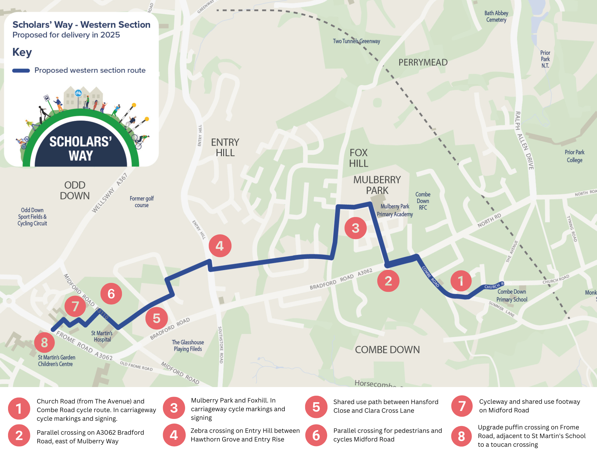
We will provide more resources to help you navigate this route soon.
View or download our flyer on Scholars' Way West.
Scholars' Way East

We consulted on proposals for the east section in 2021 and 2022, followed by an Outline Business Case. We have carried out detailed design on proposed improvements. Read about them below.
Oakley/Copseland
The scheme includes:
- a new signal-controlled crossing over Oakley opposite The Avenues
- a raised, continuous crossing over the junction of Copseland and Oakley
- narrowing of the junction of North Road with Copseland to reduce traffic speeds and improve
- improved access to the shared-use path for cyclists and people with mobility aids or pushchairs. A new bus lay-by will be installed between the junction of North Road and The Avenues
In April 2026, these measures were subject to a statutory traffic regulation order (TRO) consultation, ahead of plans to install this summer. All feedback was duly considered, and a decision was made to progress. Read the TRO decision report (see Report 5a).
Widcombe Hill/Copseland
We are also proposing walking improvements at the Widcombe Hill/Claverton Down Road end of Copseland. They include a continuous footway and dropped kerbs with tactiles. This crossing forms part of the Local Active Travel Schemes (LATS) programme being delivered as part of Scholars’ Way.
Rainbow Woods: Quarry Farm to Claverton Down Road
We plan to upgrade the existing shared path between Quarry Farm and Claverton Down Road to a hard surface (3m wide), to improve conditions for walkers, wheelers and cyclists.
Construction dates
Due to locations of the works, we will keep disruption to a minimum. Timings below may change.
| Site name | Earliest start | Earliest completion | Works summary |
|---|---|---|---|
| Oakley/Copseland | Paused | Unknown | Toucan crossing Shared use path Continuous crossing Bus lay-by |
| Widcombe Hill/Claverton Down Road | TBC | TBC | Continuous footway, dropped kerbs with tactiles |
| Rainbow Woods Quarry Farm to Claverton Down Road | Summer 2026 | Autumn 2026 | Upgrading existing shared-use path |
Keep informed
To get updated about the progress of the project you can sign up to our mailing list.
You can also subscribe to our newsletter, E-connect, or follow us on Facebook and Instagram.
If you have feedback or questions about this scheme, please email us at scholars_way@bathnes.gov.uk, or call council connect on 01225 39 40 41 and ask to speak to a member of the Scholar's Way (CRSTS) team.